Projects ArcGIS Collector App – Homeless Camps
Most cities in California are facing the challenges that come with an increasing homeless population including litter, disease, environmental damages, public safety issues, affected property values, and, most significantly, the toll that living on the street takes on the mental and physical health of these individuals.
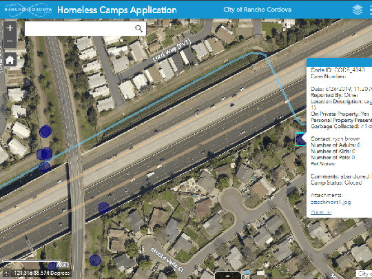
While resources and solutions are available, communication with and information on this population can be difficult to establish. In response to this issue in the City of Rancho Cordova, Interwest’s GIS Team created a map-based program to help document, track and clean up homeless camps in the City.
The ArcGIS Collector app allowed City staff to quickly document the location and characteristics of camps and their inhabitants on their smartphones, creating a database of information that helped assist in understanding the magnitude, concentration, and locations of different camps. Information gathered in the field can be viewed by staff back in the office for analysis on how best to direct resources for clean-up activities near street rights-of-way, highway interchanges, creekways and vacant lots.
The information gathered was also used by the Rancho Cordova Homeless Outreach Team, comprised of a Homeless Navigator, a code enforcement officer and two police officers, to assist individuals and families experiencing homelessness in the community by providing resource information to potentially help them towards a more stable future.
Note: During the COVID-19 pandemic, the enforcement of illegal homeless camps has been put on hold.